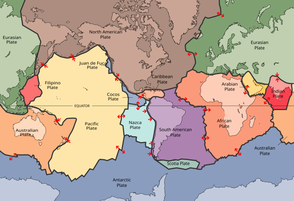
Continents drift because they ride on huge plates of rock that slide slowly over a softer layer of the mantle (U.S. Geological Survey). The mantle is the hot rock beneath Earth’s crust. Scientists are still working out what forces move those plates. New ocean floor forms at mid-ocean ridges, and old ocean floor sinks back into the mantle at trenches. The idea took more than 50 years to go from a rejected hypothesis to an accepted theory.
This page covers the whole story in one place: Alfred Wegener’s original hypothesis, why scientists rejected it, the ocean-floor discoveries that revived it, the evidence that old ocean floor is recycled, and the modern theory of plate tectonics.
What did Wegener propose in 1912?
Alfred Wegener proposed that Earth’s continents were once joined in a single landmass and have since drifted apart. He based this on matching fossils, matching rock formations, and coastlines that fit together across oceans, plus glacial deposits that only made sense if the continents had once sat in different positions (U.S. Geological Survey).
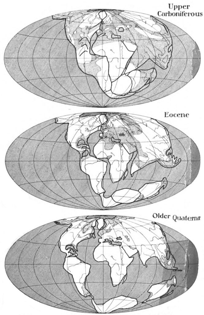
Wegener pointed to identical fossil species, such as the reptile Lystrosaurus and the fern Glossopteris, found on continents now separated by ocean (U.S. Geological Survey). Coal made from tropical plants lies in frozen Antarctica, and glacial deposits sit in present-day arid Africa. These clues fit best if those lands once sat in different places (U.S. Geological Survey, This Dynamic Earth). This section does not cover the plants and animals living today, only the physical evidence Wegener used.
Why did scientists reject continental drift?
Scientists rejected Wegener’s idea mainly because he could not explain a mechanism strong enough to push continents through solid ocean crust. Wegener suggested that the continents simply plowed through the ocean floor. The U.S. Geological Survey describes the critics’ main question this way: “What kind of forces could be strong enough to move such large masses of solid rock over such great distances?” (This Dynamic Earth).
Wegener died in 1930. Geologists debated his idea off and on for decades afterward, then largely dismissed it (U.S. Geological Survey, This Dynamic Earth). This does not mean Wegener’s evidence was wrong. It means the missing piece was a cause, not the pattern itself.
How did scientists find seafloor spreading?
Scientists built the case for seafloor spreading in the 1950s and 1960s. Sonar surveys of the ocean floor revealed a mountain range winding around the globe, called the mid-ocean ridge system, more than 50,000 kilometers long (U.S. Geological Survey, This Dynamic Earth).
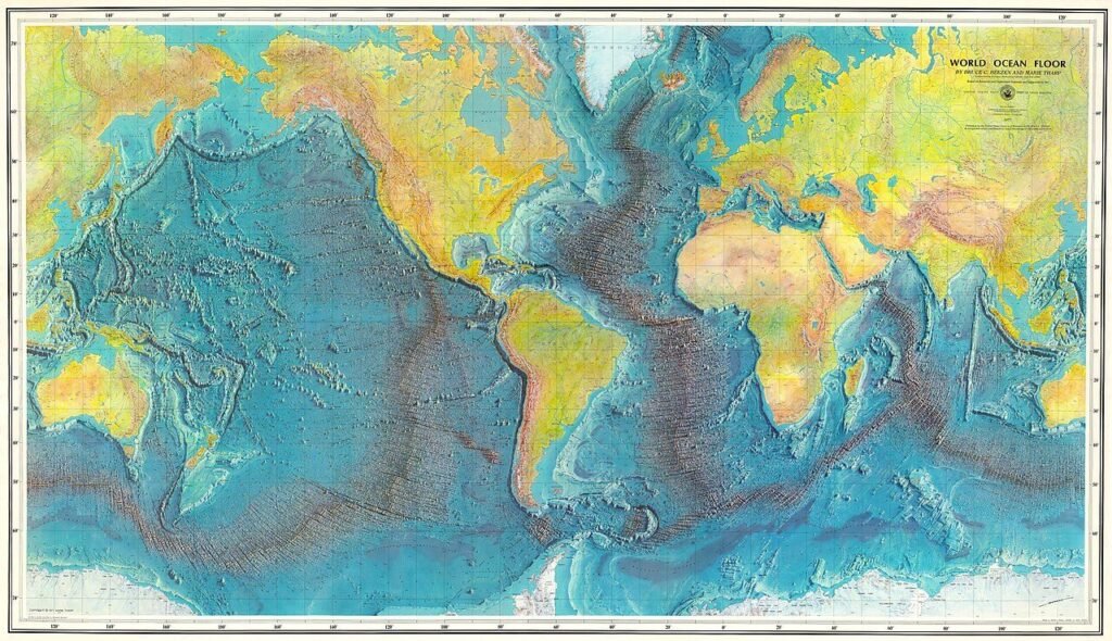
Geologist Harry Hess proposed that new ocean crust forms constantly at these ridges and moves outward like a conveyor belt. He reasoned that Earth is not growing, so old crust must be destroyed somewhere else (U.S. Geological Survey, This Dynamic Earth). This section does not cover continental crust, which does not get recycled the same way and is why continents are far older than the ocean floor.
What are magnetic stripes and how do they prove seafloor spreading?
Magnetic stripes are bands of ocean floor rock that recorded Earth’s magnetic field when they formed. They line up in a mirror-image pattern on either side of a mid-ocean ridge. Earth’s magnetic field has flipped direction many times. Volcanic rock locks in whichever direction was current when it cooled, and that direction cannot change afterward (U.S. Geological Survey, This Dynamic Earth).
When scientists mapped the stripes, they found the pattern was symmetrical. The same sequence of normal and reversed stripes appeared on both sides of the ridge, like two matching sets of tree rings. That symmetry meant new crust was forming at the ridge and pushing older crust away on both sides at once. This section does not cover magnetic fields elsewhere in the solar system. It covers only Earth’s own field history as recorded in ocean rock.
Where does old ocean floor go, and how do we know?
Old ocean floor sinks into Earth’s mantle at deep ocean trenches in a process called subduction, so the ocean floor stays young. A trench is a long, narrow canyon in the ocean floor. A number of Pacific trenches are thousands of kilometers long and 8 to 10 kilometers deep. The place where a plate sinks is called a subduction zone (U.S. Geological Survey, This Dynamic Earth).
Earth’s size has not changed significantly during the past 600 million years. That means the crust “must be destroyed at about the same rate as it is being created,” according to the U.S. Geological Survey (This Dynamic Earth). Three kinds of evidence show where the old crust goes.
First, earthquakes mark the path of the sinking plate. By the late 1920s, seismologists had found earthquake zones that reach several hundred kilometers into Earth. These zones typically tilt 40 to 60 degrees from the horizontal and run parallel to the trenches. They are called Wadati-Benioff zones (U.S. Geological Survey, This Dynamic Earth).
Second, the land itself moves. On March 27, 1964, a magnitude 9.2 earthquake struck southern Alaska. Parts of the coast sank as much as 8 feet, and other parts rose as much as 38 feet. These shifts covered an area two-thirds the size of California (U.S. Geological Survey, Alaska Science Center). USGS geologist George Plafker correctly read the quake as a subduction zone event. The Pacific Plate had lurched northward underneath the North American Plate (U.S. Geological Survey, Earthquake Hazards Program).
Third, the ocean floor is young. The oldest dated continental rocks formed about 4 billion years ago. The oldest seafloor in the ocean basins formed about 180 million years ago (U.S. Geological Survey, Volcano Hazards Program). One small exception lies beneath the eastern Mediterranean Sea. A 2016 study in Nature Geoscience estimated that crust at about 340 million years old (Ben-Gurion University of the Negev research portal).
The U.S. Geological Survey describes the recycling cycle in four steps (Volcano Hazards Program).
- Magma rises at a mid-ocean ridge and hardens into new ocean floor.
- The plate moves away from the ridge, cools, and becomes denser.
- At a trench, the cold, dense edge sinks and pulls the rest of the plate behind it. Evidence suggests this pull is the main driving force of subduction (U.S. Geological Survey).
- Fluids squeezed out of the sinking plate help melt the mantle above it. Some of that magma erupts and builds volcanoes.
Some older science pages say the sinking ocean floor melts right away. The USGS says the plate stays solid far beyond 100 kilometers deep. Geologists are not sure how deep it sinks before it begins to melt (U.S. Geological Survey, Volcano Hazards Program). If you draw the cycle, show a solid slab tilting down into the mantle, not a puddle of lava at the trench.
This cycle applies to ocean floor. When two continents collide, neither sinks, because continental rock is relatively light (U.S. Geological Survey, This Dynamic Earth).
What does plate tectonics say today?
Plate tectonics is the modern theory that Earth’s outer shell is broken into a dozen or more large and small plates that move slowly over a softer layer of the mantle. Plate motion averages from less than 1 to more than 15 centimeters per year (U.S. Geological Survey, Volcano Hazards Program). Deep-sea drilling in 1968 dated rock samples taken across the Mid-Atlantic Ridge, and the ages gave the clinching evidence that seafloor spreading was real (U.S. Geological Survey, This Dynamic Earth).
More than 80% of the world’s earthquakes and volcanoes occur along or near plate boundaries, because that is where plates grind past, collide with, or pull apart from each other (U.S. Geological Survey, Volcano Hazards Program). A few volcanoes form far from any boundary. The Hawaiian Islands, more than 3,200 kilometers from the nearest plate boundary, formed as the Pacific Plate moved over a hotspot in the mantle (U.S. Geological Survey, This Dynamic Earth).
Plate tectonics still has open questions. The USGS lists the nature of the forces that propel the plates among the chief outstanding ones, the same question Wegener could not resolve (U.S. Geological Survey, This Dynamic Earth).
For classroom activities on this topic, see our science lesson plans and the broader science section. For another Earth science topic, read about what causes the seasons.
Sources
- U.S. Geological Survey. Wegener’s Puzzling Continental Drift Evidence
- U.S. Geological Survey. This Dynamic Earth: Developing the Theory
- U.S. Geological Survey. This Dynamic Earth: Historical Perspective
- U.S. Geological Survey. This Dynamic Earth: Understanding Plate Motions
- U.S. Geological Survey. This Dynamic Earth: Hotspots
- U.S. Geological Survey. Plate Tectonics in a Nutshell (Volcano Hazards Program)
- U.S. Geological Survey. M9.2 Alaska Earthquake and Tsunami of March 27, 1964
- U.S. Geological Survey. The 1964 Great Alaska Earthquake and Tsunami
- Ben-Gurion University of the Negev. Palaeozoic oceanic crust preserved beneath the eastern Mediterranean (Nature Geoscience, 2016)
Sources & further reading
Source links are provided for editorial review. Recovered historical text has not been independently verified.